When a Kelly kid is 12, they get to go on a trip with one parent to a mutually agreed upon spot. Patrick really wanted to go on a backpacking trip on the Appalachian Trail (AT). We decided to tackle a 33-mile section in the Great Smoky Mountains National Park, heading north from Fontana Dam to Clingmans Dome. The day before our hike, we drove to Clingmans Dome, dropped the car there, and got a ride to The Hike Inn near Fontana Dam. We did a pack/gear shakedown, played catch with the frisbee, watched some baseball on TV, and checked the forecast for the next day (which was not great--thunderstorms most of the day). The next morning, we got a ride to Fontana Dam, slung our packs on, and with no other humans in sight, hiked into the foggy and rainy Appalachian Mountains.
Here is a map of our hike from morning til lunch:


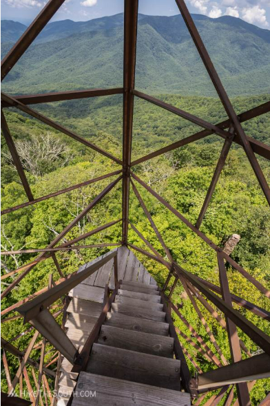
We ate lunch under our tarp at the base of Shuckstack Tower. Since we didn't hear any thunder, we climbed up the tall, rickety, abandoned tower in the hard rain for a view of nothing but dense fog, just to say we did it.

Here is what we would have seen on a clear day from Shuckstack Tower:
Things got a little brighter after lunch. We slogged another 8 miles to our lodging for the first night, Mollies Ridge shelter. Totals for the day were 13+ miles and 4,500 feet in elevation.


After a little nap, we took a hike without our packs to Rocky Top viewpoint for our first really nice view of the trip. After a day and a half of only thick woods and a lot of rain, we welcomed the payoff!

Spence field had some permanent residents in a wild boar and her piglet. They made lots of loud snorting and digging noises and made a few appearances around the shelter during the evening. Earlier in the day, we passed a hiker who had just seen a large black bear in the direction we were going, but we did not encounter any bears ourselves. In the evening, we cooked our dinner, played some frisbee, and then turned in. The man in the tent next to ours talked loudly to Siri and then immediately started snoring.


On day three we hiked to Silers Bald. We had planned to stop at Derrick Knob, but we got there by lunch and it was overrun with bees, so we kept going to Silers Bald.
Here is a map of segment one between Spence Field and Derrick Knob:

Here is a map of segment two between Derrick Knob and Silers Bald (totals for the day were 12 miles and 3,700 feet in elevation):

Silers Bald shelter:

On our last day, we set out for Clingmans Dome. The day started off beautifully, but fog gradually set in. Here is a map of our final segment (4.5 miles, 1,700 feet in elevation):


No comments:
Post a Comment